

The Gateway Restaurant (Three Rivers, CA)
May 15, 2021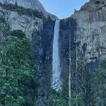
Yosemite National Park: Bridalveil Falls (California)
May 17, 2021The Gateway Restaurant (Three Rivers, CA)
May 15, 2021Yosemite National Park: Bridalveil Falls (California)
May 17, 2021Yosemite National Park: Photo-Ops Along the CA-120 E and Big Oak Flat Road
QUESTION: What are your Top Things to See or Do While in Yosemite National Park?
Mention @JustWanderMaya and hashtag your photo with #JustWanderWithUs
First day to explore Yosemite National Park. Never been here before so we give ourselves an early start from Yosemite Pines RV Park. Sporting my Sequoia National Park souvenir beanie, it’s 6:15am and we’re jumping in the car to jump on the CA-120E towards Big Oak Flat Road.

We wanted to beat any crowds because we’ve read:
"Yosemite sees almost 3/4 of its visitors in six months. Millions of visitors from around the world come to witness the beauty of Yosemite firsthand, and we can definitely see why. Although the park is open all year, nearly 75 percent of visitors come to the park May through October, and most of them never leave the 6-square miles that is Yosemite Valley." – Dept of Interior
Sun’s already coming up!

Four Photo-Ops Before Visiting Yosemite Visitor Center
(6:50am) 1st Stop: Yosemite National Park Sign


(7:15am) 2nd Stop: Half Dome View
Our second stop was at Half Dome View off Big Oak Flat Road.

"A bronze sculpture of Half Dome was installed at Half Dome Overlook, a scenic viewing area along Big Oak Flat Road, as part of a restoration project supported by Yosemite Conservancy donors." – Yosemite Conservancy


The other viewpoints of this iconic rock:
- Tunnel View
- Glacier Point
- Washburn Point
- Mirror Lake
- Cook’s Meadow
… and from the various hikes: Sentinal Dome, Sub Dome, Top of Half Dome, etc.
(7:25am) 3rd Stop: The Cascades
We’ve parked along the side of a bridge on Big Oak Flat Road to witness a glimpse of the falls we saw as we approached the area.

"The Cascades occurs at the confluence of Tamarack and Cascade Creeks, two miles west of Yosemite Valley, and falls a bit over 600 feet (180 meters) starting near the Big Oak Flat Road and finishing just above Highway 140. It looks most impressive during the spring." – Yosemite Hikes


GPS Location: 37° 43' 39.528" N 119° 42' 47.592" W
(7:40am) 4th Stop: Tunnel View
On to the next photo op… The Tunnel View is found at the east end of the Wawona Tunnel along Wawona Road (Highway 41), a 30 minute drive south from Yosemite Village.

Probably one of the best times to photograph from the Tunnel View is sunrise (otherwise, I imagine to save the best view for last... around sunset). Sunrise on this day occurred at 5:44am. Now 7:40am what we saw was a breathtaking but blinding glare while dealing with the morning chill (48°F). Here’s what we captured:

You can witness why it’s one of the most famous views in Yosemite Valley as you get to see many of Yosemite’s highlights: El Capitan, Bridalveil Fall and Half Dome in the background.
Zoomed in on Bridalveil Falls

Nostalgic sepia version of the view:

Yosemite History & Facts
"Yosemite might be our nation’s 3rd national park, but it sparked the idea of national parks. Twenty-six years before it was a national park, President Lincoln signed the Yosemite Land Grant on June 30, 1864, protecting the Mariposa Grove and Yosemite Valley. It was the first time the government protected land because of its natural beauty so that people could enjoy it, and we’re still benefiting from their foresight today." – U.S. Dept. of Interior
A Scottish immigrant spearheaded Yosemite National Park’s creation.
John Muir, a native of Scotland who grew up in Wisconsin, first set eyes on the Yosemite Valley in 1868. "No temple made with hands can compare with Yosemite," the amateur naturalist wrote. Muir lamented the destruction of the forests and vast meadows that surrounded the state-controlled Yosemite Valley. His popular articles in newspapers and magazines raised the awareness of the region’s beauty and contributed to the eventual establishment of Yosemite National Park in 1890. – History.com